
|
|
Monday October 17th and Tuesday October 18th produced two days in a row of wild weather across parts of Ireland. During Monday an active cold front crossed over N. Ireland associated with a deep low pressure system located over the NW Atlantic, a convective forecast had been issued for squall line development with a LEWP and a risk of severe wind gusts, hail, lightning, tornadoes, and with such cold air aloft - snow couldn't be ruled out. During the 18th I watched the squall line from my girlfriend's house in south Belfast and could clearly see the menacing black skies as it approached with a gust front-type feature over the city roof tops bringing with it intense rainfall with hail and a downdraught of wind so strong it shook the lamp posts with intent, the temp dropped like a stone and the rain felt icy and bone chilling and more akin to the feeling under a snow storm rather than a rain event. The underside of the gust front sported dynamic motion and ahead of the system I could see striking convergence with the squall line moving L to R and other dark clouds moving R to L and merging at a single point where I am sure there must have been rotation over the city, however I lost sight of the structure behind the obscuring precipitation curtains. I went to the city library for a quick check online to see what others were reporting when I was shocked but thrilled to see that the cold front had produced snow over the hills of Derry, Donegal, Scotland, and most importantly over the Glenshane Pass which is near where I live, this probably could be a record early snow event for N. Ireland or at the very least the earliest here within the last 50 years.
The squall line intensified over S and SE Belfast and did develop a LEWP (Line Echo Wave Pattern) which is a radar feature akin to a bowing segment which marks areas in the convective line where severe weather could be happening which in the case of a squall line is usually powerful straight line wind gusts or tornadoes. The line moved away from Ireland then crossed the Irish Sea into mainland Britain where it actually did produce a damaging tornado so the forecast was certainly a good call. I had my eye on the following day, October 18th, which had the potential to be just as severe with the added bonus of more photogenic rewards. The airmass behind this cold front was unstable due to freezing upper air passing over a warm sea creating instability and hence the potential for convective showers of hail (and possibly snow) with a risk of thunderstorms due to the freezing cloud tops and excellent lapse rates. Since this clashing airmass was most unstable over the sea the best place to be for storms would be the costal regions, and indeed it is here during the Autumn and Winter months where any self respecting storm chaser should be hunting if he or she wants to catch thunderstorms and tornadoes. During the morning the flow would be a Wly then it would steer around to a NWly by afternoon which meant any coastal cells would be moving close to shore or even blowing over land so there was great potential. This is a segment of the forecast issued by UKASF...
Cold air aloft (T500's of -35C etc) atop warm SSTs will steepen lapse rates and generate a few hundred J/kg CAPE. As a result, numerous showers and a few thunderstorms will develop with ELTs as low as -50C locally. Due to the nature of coastal showers, lightning is possible throughout the period, regardless of daytime heating. Small, locally moderately-sized, hail is possible in many of the showers given the cold air aloft. Weak DLS in areas of interest, but significant (>30kts) LLS would allow the potential for an isolated tornadic event, particularly across Northern Ireland and NW England where conditions will be most favourable. Showers will persist well into the evening close to exposed coasts, but will die inland as daytime heating rapidly subsides.
I was still in Belfast when I was reading this forecast via my girlfriend's mobile phone internet service and I had already decided then and there that I would be chasing this day when I got home, Roisin knew more than anyone else that one of my photographic goals was to catch a stunning waterspout/tornado over the Ocean so perhaps today was going to be the moment I had been waiting for, I had spent more times chasing to the coast this year than I have at any other time in my entire life so the odds were improving so I decided that morning that once I got home I would hit the coast as soon as possible. I left the Europa bus station in the city by late morning and as soon as the bus cleared the buildings of Belfast I was shocked to see two huge cells tens of miles away along the northern skyline and considering their distance they must have been huge in size and located over the ocean, I was highly impressed by the completely solid nature of both cells, the W cell had a perfectly straight vertical leading edge from top to bottom which reminded me of a breeze block, these two monsters then developed a stunning pair of solid anvils which looked as good as - or even better - than the kind of cells one would expect on a very unstable Summer's day, to say I was impressed was an understatement, seeing those two beasts lit pure white by the morning sun and surrounded by a clear blue sky really got me in a panic for I just wanted to be at the north coast there and then because I was sure that such impressive specimens in this kind of sheared air would be producing tornadoes/waterspouts over the sea. All I could do was watch helplessly so I tried to do something positive by taking images through the bus window which I succeeded in doing despite a few strange glances from the other passengers. The images didn't do justice to the scene and I ended up deleting them but now I wish I had kept them so I would have more images to use for this report.
50 min's later I had arrived back in my home town where I had a quick lunch, checked the radar, then began my drive to the Co. Antrim coast, my plan was to park beside the sea on the north coast and go patrolling and just let nature do it's thing on that strong NWly flow. By early afternoon I was at the coast, I parked along the side of the road in Portstewart beside the promenade not far from the harbour and went for a quick shopping spree. With Winter fast approaching I was in desperate need of some new outdoor clothing to keep me dry and warm during the months ahead so I purchased several packets of thermal socks, vests, hat, wind proof and water proof gloves - which by the way have a very slim profile enabling me to work the camera with them on which is a first for me - and a fantastic wind proof and water proof jacket, I put the jacket on straight away and went back out onto the street. I crossed the road to where my car was parked, pressed the key fob, opened the door and had a quick glance over my shoulder and saw this...
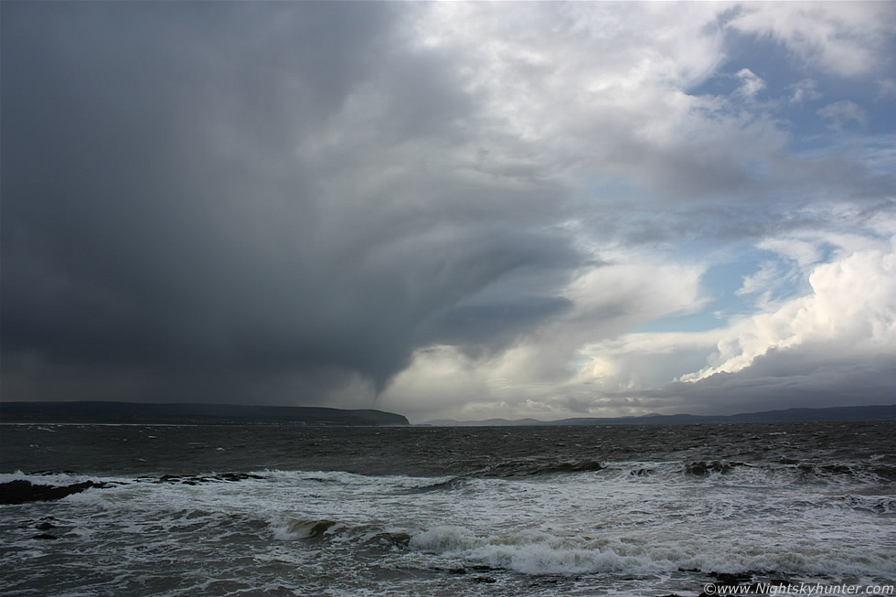 |
Looking NW across the ocean I saw a dark convective cell moving from ocean to land, R to L on image with a heavy precip core of rain and hail, then a strange lowering suddenly appeared under the base to the rear of the cell at the inflow region which began to rapidly take shape into a suspicious form. At first I thought it was a narrow precip shaft but the more I watched the more I began to wonder so I stopped thinking for a moment and began shooting, I managed to get three images in total before the lowering vanished but during that time I could see an interesting funnel shape which seemed quite consistent in form during the entire period of observation. Could this have been a funnel cloud or even a waterspout?, I didn't see any rotation however this was not surprising considering the distance involved between me and the suspect funnel which was many miles away and probably even further than I perceived it to be at the time, which was 15.23 BST. The above image was taken at 18mm so this is a wide angle capture which I deliberately took to show more of the sky and surrounding coastal features to provide a sense of scale and distance.
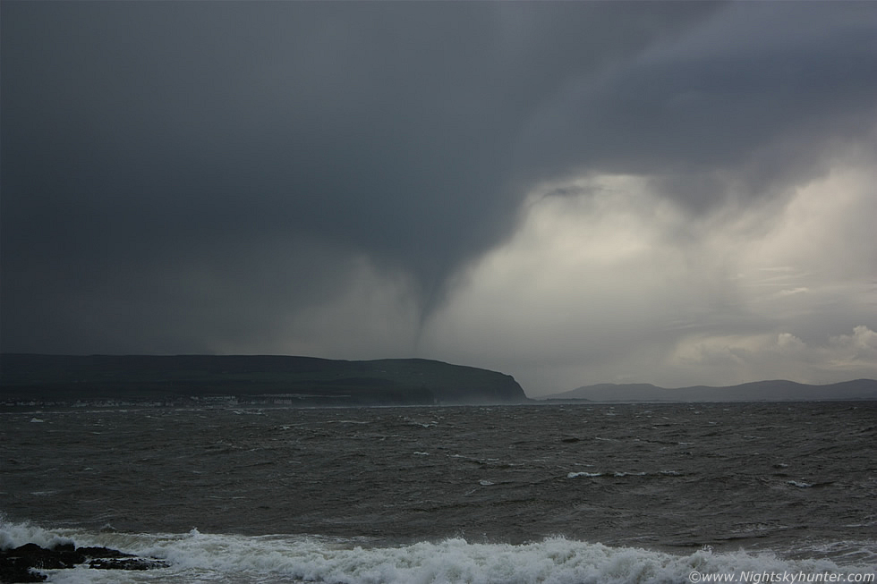 |
This was at 55mm which was the maximum zoom I could get from the 18-55mm kit lens I was using which wasn't too bad all things considered. I had the Canon 100-400mm IS USM lens sitting in the car beside me but I simply didn't have time to switch lenses so I had to make do with what I had. What got my attention was the narrow tubular feature which does look like a narrow vortex with a distinct broad collar above it attached to the base of the cell, based on these visual features alone I feel very confident in saying that this was indeed a brief funnel cloud, but could it have been more?. It's possible that this also could have been a waterspout - a tornado over water - however in order to confirm that one needs to see some kind of effect on the surface of the sea directly below the funnel such as a spray bowl but in this case the identification is not so clear cut because the region below the funnel was blocked from view by the cliffs along the shore. The distant hills on the horizon to the RHS are the mountains of Donegal, the coast feature extending out from the LHS blocking the funnel is Magilligan Point in N. Ireland, that coastal feature actually curves back inwards at that point quite sharply so the sea is actually located behind it and runs far into the shore where it meets Lough Foyle so in essence everything behind those cliffs is water which would support the waterspout theory. From looking at deep crops of the high res versions of these images I am fairly certain that the suspected funnel is behind those cliffs and over water. Using Google maps I estimated that as the crow flies the funnel was easily 9 or 10 miles away from where I was standing, this means that despite it's flimsy appearance the funnel itself must have been several hundred feet in length!.
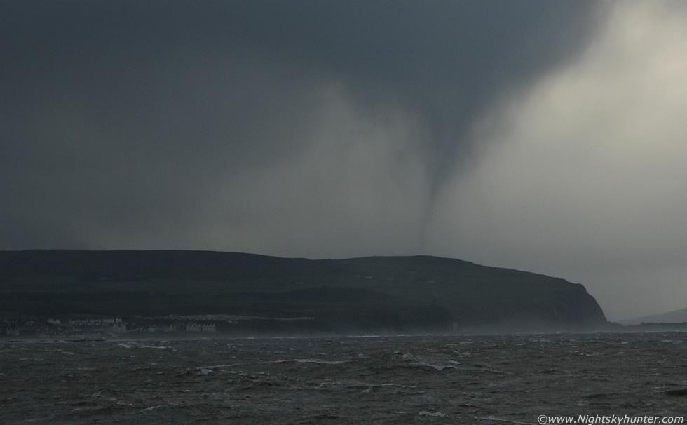 |
This is a crop of the above 55mm still. The row of white houses are beside Castlerock Beach, if you follow that line out to the R you will come to the end of a cliff face, on top of that cliff you can see a dark rounded form almost below the funnel, that's the famous Mussenden Temple. The cliff then curves back again and meets Benone strand which is hidden from view here. The next cliff face is Magilligan which I mentioned previously with the suspected location of the funnel/waterspout. I couldn't put this case entirely to rest so I contacted Dr. John Tyrrell from the Tornado and Storm Research Organisation (TORRO), Dr Tyrrell is a renowned Irish tornado investigator and I have sought his help many times in the past with other cases so I knew he would be the man to ask for a second opinion. Dr Tyrrell's conclusion was that this was likely a funnel cloud at least and at the time of writing he is in the process of hunting down other witnesses and acquiring the soundings to workout the synoptic conditions at the time. If another observer could be found then our two observations could be used to determine exactly where it was, how far away it was, and it's length/height in the sky. I doubt there will be any new witnesses due to the short duration of the vortex (1 min) and the fact that it was a Tuesday afternoon in horrendous weather conditions. I will add an update to this page if any new information comes forward.
I stayed at the coast until dusk that evening and in the fading blue light I could see towering cumulus clouds catching the last warm colours of the sun over Dunluce Castle which made for a nice end to the day, it was obvious that the best action had ended with the funnel sighting and as the hours ticked by stable air was moving in to make the atmosphere peaceful again. My last sight of the day was a coach of tourists stopping with dozens of people running outside taking images of the castle, then they got hit by powerful squalls mixed with hail to the extent that I could see their coach rocking on its suspension, they didn't survive long before running back to the warm sanctuary of the heated interior, I think they got a taste of how nasty the weather in N. Ireland can be which I'm sure was in complete contrast to the sunny pictures they had seen in magazines!. I drove home feeling tired but not wet or cold, my new jacket had got pressure tested the moment it came off the hangar and it passed with flying colours so I felt happy knowing I had new weather gear along with a possible funnel/waterspout bagged at the same time. This shoot really has motivated me to continue in search of more vortex events along the coast, I really do think there is significant potential in this area to catch ocean tornadoes so it has become my goal now to capture an extremely photogenic specimen on camera and I have a feeling I will achieve that goal sooner rather than later. Until the next chase - thanks for reading.
Martin McKenna